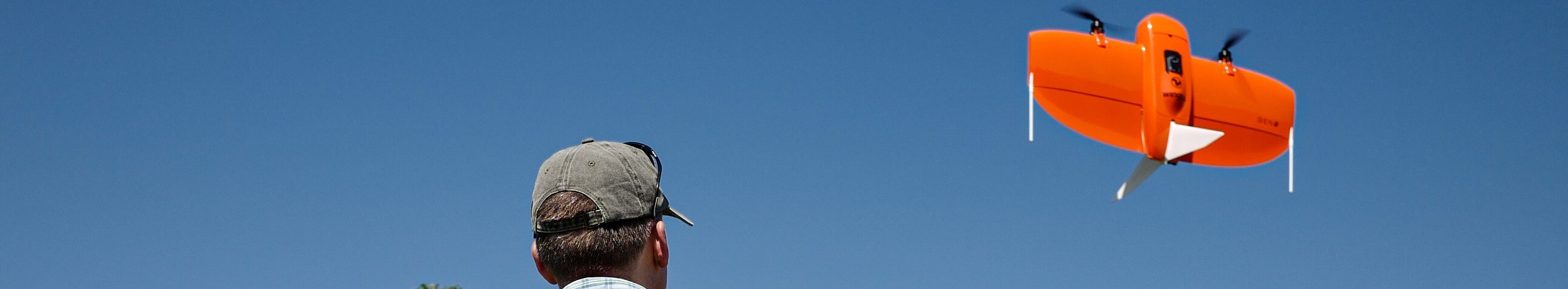
Fig. 1: UAV flight over the Naturwald Vierzehnheiligen forest reserve in Oberfranken (Upper Franconia) Photo: Patrick-Benjamin Ibron
Aerial photographs document the condition of forest stands at the time the images are taken and can therefore help with the detection of discoloured or damaged spruce trees. Orthophotos derived from the original aerial images (i.e. distortion-free and true-to-scale aerial image data) provide precise information on the exact location of the damaged areas. The Bavarian State Ministry of Food, Agriculture and Forestry therefore commissioned the Bavarian State Institute of Forestry (LWF) to carry out large-scale aerial surveys in Upper Franconia in autumn 2021 and 2022. The aerial data helped the forestry offices (AELFs) responsible there with the detection and recording of bark beetle damage and the resulting clear areas.
Because of the large areas covered, with surface areas of 2,840 km² in 2021 and 4,220 km² in 2022, these image flights were carried out with aeroplanes. The image material was then to be made available as quickly as possible, so the commissioned companies had to convert the recorded stereo aerial image data into orthophotos with a spatial resolution of 20 cm in as short a time as possible. To keep the data volume as small as possible and thus ensure fast processing, the overlapping of the individual stereo images was reduced as much as possible, to 70 % longitudinal overlap in the direction of flight, and 30 % transverse overlap of the flight strips. In order to shorten the processing time even further, lower accuracy requirements were specified for the orientation of the stereo aerial images than for a classic image flight. In addition, the orthophoto calculation was carried out using an existing official terrain model for Bavaria, so that a further time-consuming calculation step - namely the derivation of a surface model from the stereo images - could be omitted. The image data, produced in this way more quickly than image data from conventional image flights, are thus referred to as “fast orthophotos”. In the “FastOrtho” research project, the LWF tested the possible applications of fast orthophotos and the workflow for providing them.
As well as the aerial images taken from aeroplanes, images were taken using unmanned aerial vehicles (UAVs/drones). In the research project, the LWF analysed the different characteristics of the aerial images taken from the plane and those taken from the UAV. They also tested how quickly the image data could be generated by the respective aircraft and made available to forestry practitioners.
To allow them to investigate this, an aerial survey of the 541 hectare Naturwald Vierzehnheiligen forest reserve was carried out by UAV on 29 September 2022 (Figure 1). Ten days later, this area was also photographed from an aeroplane for the purposes of the fast orthophoto flight mentioned earlier. Although the Naturwald Vierzehnheiligen forest reserve is dominated by near-natural mixed deciduous forests, numerous discoloured spruce trees were nevertheless also found for the study. Because the aeroplane and UAV flights were carried out within a short space of time, the two image data sets could be compared very well.
UAV flight over the “Naturwald Vierzehnheiligen” forest reserve
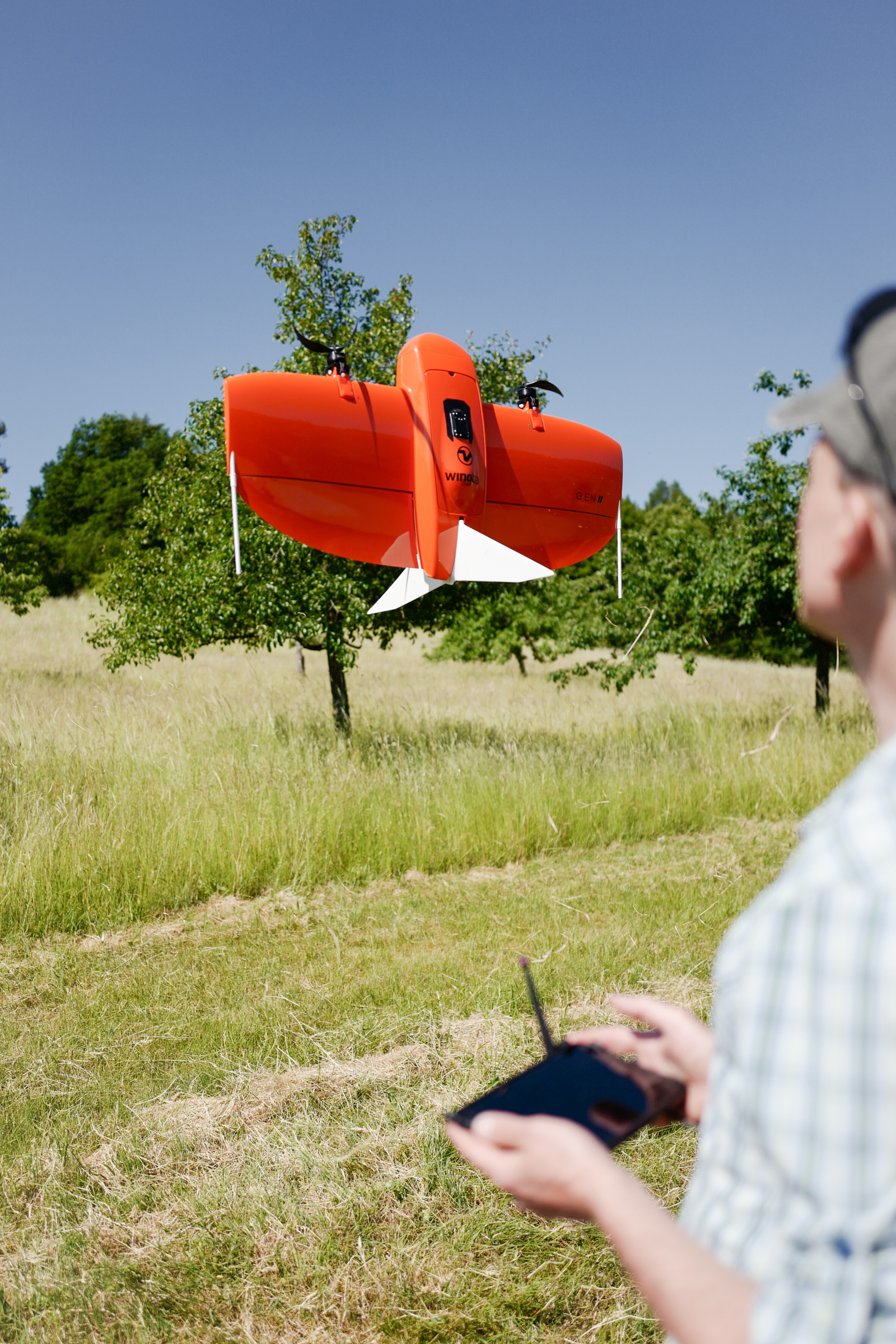
A vertical take-off fixed-wing drone was used for the UAV flight. This technology allows the drone to take off and land flexibly in confined areas, like a helicopter. As soon as the drone has reached a sufficient height above the treetops, it switches to forward flight mode. With this technology, significantly larger areas can be covered than with conventional quadrocopters. The UAV device was equipped with a high-resolution RGB camera, which - like conventional cameras - takes photos in the visible spectral range. The aircraft was also equipped with a high-precision GPS receiver. This served as the basis for recording the image data with a positional accuracy in the decimetre range.
A total of six individual flights from different take-off sites were necessary for the aerial survey of the forest reserve. Each individual flight took off from a different launching site. To map the forest areas, a flight plan with parallel flight lines was created for each flight, systematically covering the respective sub-area. The entire UAV aerial survey was completed within half a day.
The UAV takes over one thousand individual photos per flight, which overlap considerably. The high degree of overlap is a requirement for the subsequent processing of the images. This was carried out using a special software package, with which both a high-resolution surface model and a coherent orthophoto (image mosaic) with a spatial resolution of 3 cm were created.
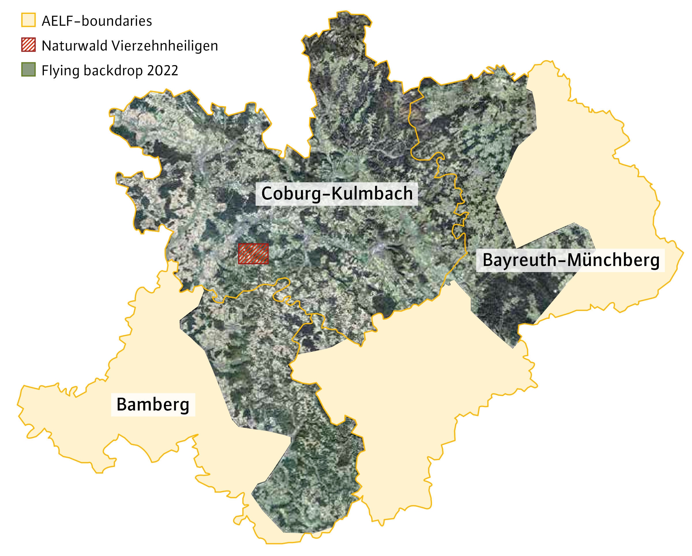
Fig. 2: The red shading on the map indicates the location of the forest reserve; in the background is an orthophoto mosaic of the entire fast orthophoto image flight, which was carried out by an aeroplane in the autumn.
Positional accuracy of tree positions
To assess the positional accuracy of tree positions in the orthophotos derived from the fast orthophoto and UAV aerial surveys, a comparison was made with official (true) orthophotos of the Bavarian Surveying Authority, which are very accurate in terms of position. For this purpose, random easily recognisable tree tops were marked manually in the UAV orthophoto and in the fast orthophoto and compared with the position of the corresponding tree tops in the official orthophotos. The distances determined in pairs in this way represented the positional deviations of the tree positions on the project orthophotos from the tree positions on the official orthophotos.
The UAV dataset of the Naturwald Vierzehnheiligen forest reserve showed a high level of positional accuracy when compared with the official orthophotos: The mean deviation of the measured tree tops was just 0.62 m, with a standard deviation of 0.22 m. In the fast orthophotos the mean deviation of tree tops was 2.48 m, with a standard deviation of 2.41 m compared to the official data.
The larger positional deviations in the fast orthophotos in comparison with the UAV image data are due to the reduced longitudinal and transverse overlap during the image acquisition, the less stringent accuracy requirements for the orientation of the stereo aerial images, and the use of a terrain model for orthorectification. Corresponding positional inaccuracies must be accepted here. However, the geometric accuracy of the fast orthophotos is sufficient to assist with the detection of damaged and dead spruce trees.
Recognisability in the aerial image data
The possibilities and limitations of visual recognition of discoloured spruce crowns in the UAV orthophotos in comparison with the fast orthophotos taken from the plane can be summarised as follows:
- In the upper layer visible in the aerial images, spruce trees that have turned reddish-brown and grey are very clearly recognisable both in the UAV orthophotos (Figures 3a, 3c and 3e) and in the fast orthophotos (Figures 3b, 3d and 3f).
- As expected, more crown structure can be seen in the UAV orthophotos due to the higher spatial resolution. Colour variations such as the complete or partial discolouration of individual crowns are easier to identify (Figure 3a); UAV image data are therefore somewhat more suitable for identifying the onset of reddish-brown discolouration. This slight discolouration of the crowns is not as pronounced in the fast orthophoto (Figure 3b), but can still be seen.
- In Figure 3d, the reddish-brown discolouration appears somewhat more clearly in the fast orthophoto than in the UAV orthophoto (Figure 3c). Distinguishing this from the spruce trees with grey discolouration is somewhat easier in the fast orthophotos.
- In the UAV image data, gaps in the canopy are better illuminated (Figures 3a and 3e). In comparison with this, the shading in the crown gaps is more pronounced in the fast orthophotos (Figures 3b and 3f), which means that smaller trees with discolouring in the shaded area are no longer visible in some cases.
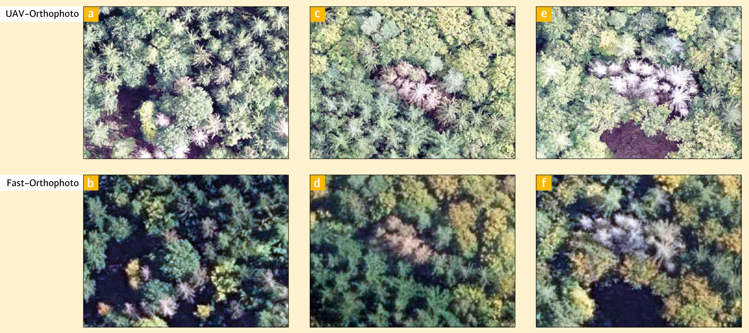
Fig. 3: Comparison of image sections of a UAV orthophoto (top) and fast orthophoto (bottom); the left pair of images (a and b) contains examples of spruce trees discoloured grey as well as examples of crowns beginning to turn reddish-brown. In the middle (c and d) you can see spruce crowns with reddish-brown discolouring and on the right (e and f) spruce discoloured grey.
How quickly can the orthophotos be created?
Figure 4a shows the relationship between the area size [km²] of an aerial survey area and the time taken [in working days] to create fast orthophotos. The time taken to prepare the orthophotos is understood here as the number of flight days required plus the lag time needed to calculate the orthophotos. This relationship was derived on the basis of three fast orthophoto image flights commissioned by the LWF for different project areas. However, the presentation is based on the assumption that there are no delays due to unfavourable flying weather. In practice, however, there may well be delays.
Figure 4b shows the estimated time taken for the preparation of UAV orthophotos. The presentation is based on the LWF's experience to date. The preparation time shown here is based on the assumption that the area is divided up and flown in parallel by two drone pilots with two drones. As with the aerial survey carried out by plane, it was assumed that there would be no delays due to unfavourable weather conditions.
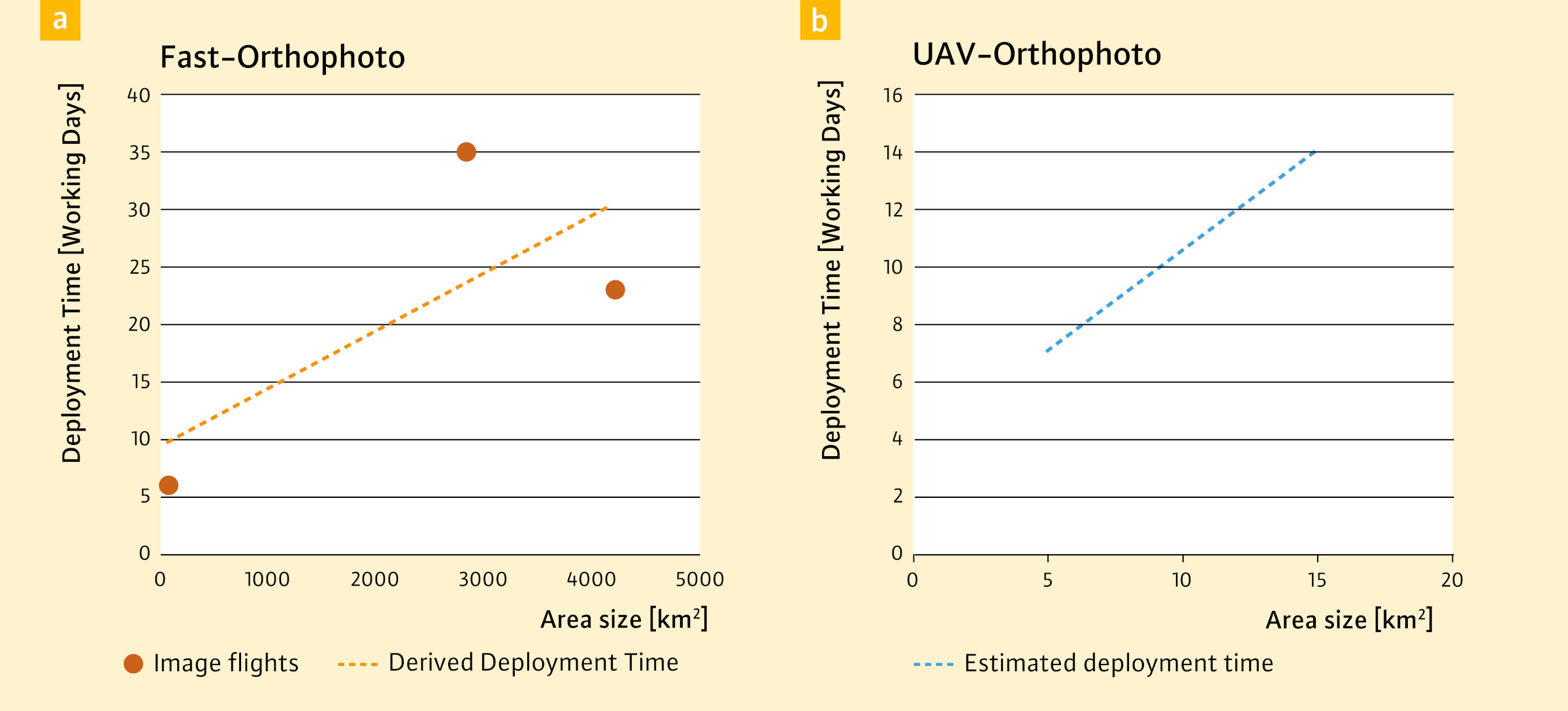
Fig. 4: Based on three image flights commissioned by the LWF, a correlation was derived between the size of the aerial survey area and the time taken* for the creation of fast orthophotos (a) as well as the estimated time* necessary for the creation of UAV orthophoto data (b) as a function of the size of a flight area.
* Time taken for preparation of images: number of flight days required + duration of orthophoto calculation
The bottom line
Figure 5 shows selected characteristics of the UAV orthophotos and fast orthophotos. Basically, the FastOrtho research project showed that in the visible upper layer of the aerial images, reddish-brown or grey discolouration of spruce trees is very easily recognisable visually in both the UAV photos and the fast orthophotos. Both data sets can therefore be used for the manual mapping of these later stages of infestation. However, early detection of infested spruce trees with still green crowns is not possible with the aerial image data from either the UAV or the aeroplane.
The findings from the project so far provide initial indications for future applications that may allow us to weigh up which flight system is more suitable for the respective problem. Numerous factors such as area size, area shape, topography and the required ground resolution of the image data play an important role in this consideration. In general, it can be said that a UAV flight is recommended for smaller areas if very high-resolution image material is required. Fast orthophoto image flights are suitable for large-scale operations with lower demands in terms of positional accuracy but where faster reaction times are necessary (e.g. bark beetle infestation). Positionally accurate true orthophotos from a large-area aerial survey are recommended for applications requiring a high degree of accuracy but with less time pressure.
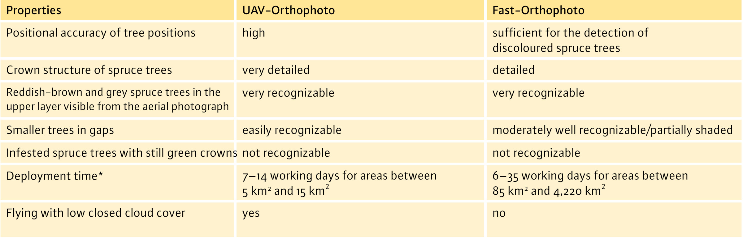
Fig. 5: Overview of selected features of aerial images from aeroplanes and UAVs. * LWF experience to date, assuming good flying weather
Outlook
With the appropriate software, stereo aerial images can be viewed and analysed stereoscopically or three-dimensionally on a 3D monitor. The spatial impression allows individual trees to be better differentiated and more reliably analysed in comparison with the 2D interpretation of orthophotos. In addition, tilting is compensated for in the stereoscopic view, so that a geometrically more accurate recording of position is possible.
Data from aeroplane flight surveys is already analysed stereoscopically for numerous tasks at the LWF. In future, data from UAV flights is also to be trialled and incorporated. There are also plans for further studies to investigate the use of multispectral data in more detail. In addition to the visible spectrum, the “red-edge” and “near infrared” spectral ranges will also be used. The testing of automated evaluation methods is also planned in order to make image analysis more efficient where necessary. In this context, we see potential in the use of modern AI methods.
Summary
Bavaria has had large quantities of timber damaged by spruce bark beetles in recent years. The efficient and rapid detection of damaged areas is very important. In the “FastOrtho” project, the LWF thus investigated how spatially high-resolution aerial image data from aircraft and UAVs can help with the detection of discoloured spruce trees in the forest. It turned out that reddish-brown or grey discolouration of spruce trees is visually very easily recognisable in the image data collected by both UAVs and aircraft. All in all, the project provides a basis for making decisions in future on which flight system is best suited for a particular problem.

