Drought and heat favoured the spread of spruce bark beetles again in 2022. As in previous years, the spruce forests of northern Bavaria were particularly affected, and an expansion of the threat to the south was also observed. The highest densities of the European eight-toothed spruce bark beetle and numbers captured were found in the Franconian Forest, where the dramatic bark beetle infestation has now resulted in large clear areas (Figure 1).
Aerial photographs taken from an aeroplane are a useful tool for gaining an overview of the extent of bark beetle damage. In recent years, the Bavarian State Institute for Forests and Forestry (LWF) has thus received an increasing number of requests from forestry practitioners for aerial image data to assist them with damage detection on site.
Digital orthophotos, which are derived from the original aerial image data through mathematical rectification, are the key tool here for localising damaged forest stands or even individual tree crowns. The orthophotos can be presented together with other geodata in a geographic information system (GIS) such as the Bavarian Forest Information System (BayWIS).
In the event of mass propagation (of the eight-toothed spruce bark beetle, for example), data must be provided as quickly as possible. As part of the “FastOrtho” project in 2021, the LWF thus tested a workflow designed to provide digital orthophotos as quickly as possible. The aim was to shorten the lag time between image flight and data provision as much as possible without causing unacceptable losses of precision in the detectability of damage. The image data created in this way are also known as “fast orthophotos” due to their faster processing.
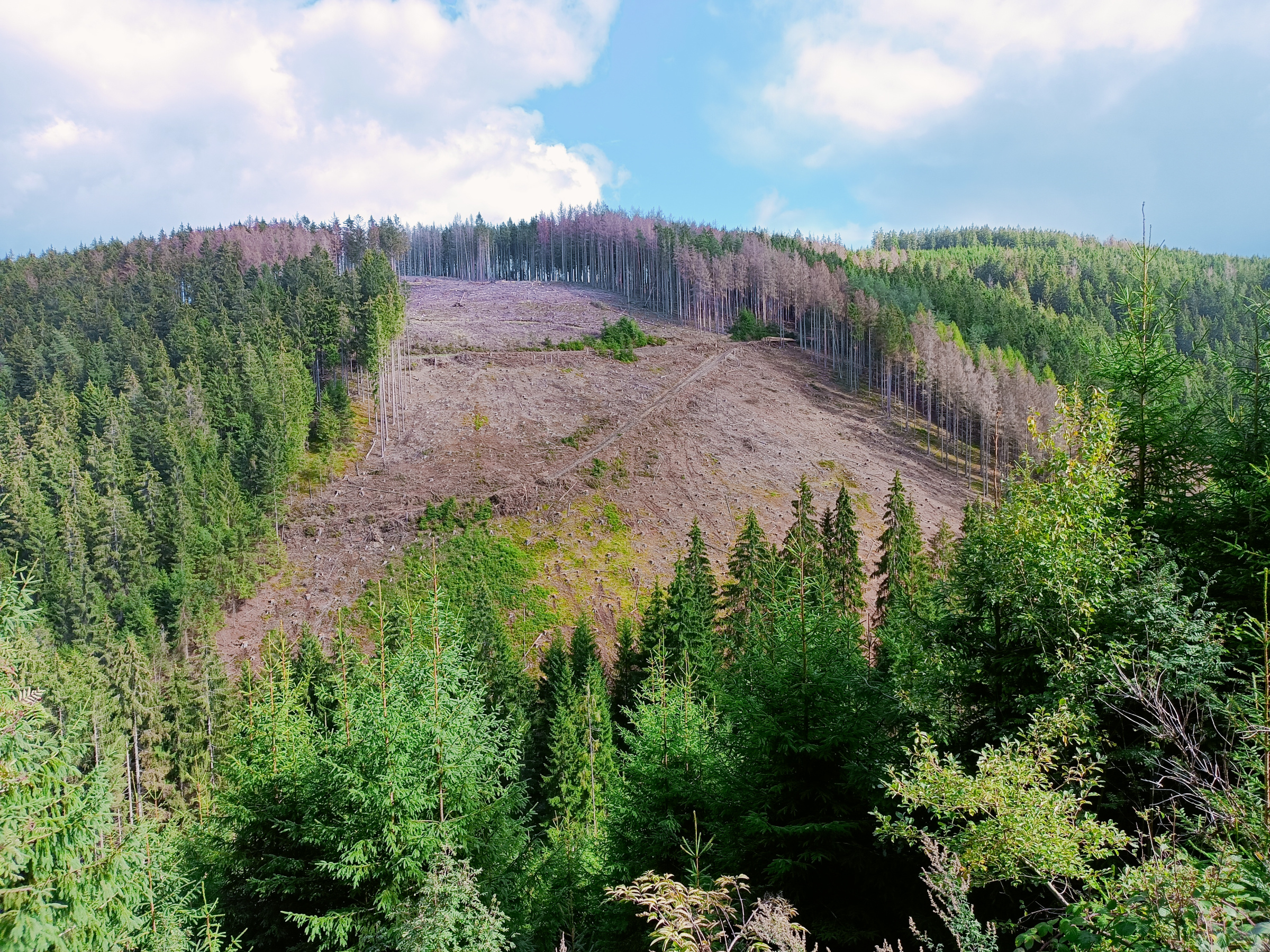
Fig. 1: Bark beetle damage, such as here in the Frankenwald forest, can only partially be recorded in field surveys. Aerial photographs provide a more comprehensive insight into what is happening. Photo: Eike Reinosch (LWF)
What are fast orthophotos?
High-quality aerial photographs are gained on image flights using special measuring cameras. This allows digital image data to be produced as panchromatic, true colour and colour infrared images with high spatial resolution. Depending on the size of the survey area and the specified spatial resolution and overlap of the individual images, classic image flights can generate very large amounts of data. These lead to complex processing and it thus takes a relatively long time to provide the image data. The following specifications are intended to ensure that forestry practitioners receive high-quality image material and that the period of time between the flight and the provision of data is as short as possible:
- High spatial resolution of 20 cm × 20 cm for the creation of the fast orthophotos
- Systematic recording of aerial images at fixed intervals along parallel flight strips
- Lower accuracy requirements for the orientation of the stereo aerial images in fast orthophoto image flights compared to classic image flights
- Conversion of aerial images into a distortion-free and true-to-scale orthogonal perspective with the help of an official terrain model
The spatial resolution data refers to the ground area that a pixel in the aerial photo represents on the Earth’s surface. The high spatial resolution ensures that tree crown structures and crown discolouration are easily recognisable in the image data.
During the systematic recording of the aerial images, neighbouring images overlap to allow a complete, stereoscopic evaluation of the entire survey area. A distinction is made here between the longitudinal overlapping of the individual images in the direction of flight, and the transverse overlapping of the adjacent flight strips. For the production of fast orthophotos, 70 % longitudinal overlap and 30 % transverse overlap are specified. In comparison, the Bavarian Surveying Administration specifies at least 80 % longitudinal overlap and 50 % transverse overlap for the production of official orthophotos (LDBV 2023). The smaller single image overlap in a fast orthophoto image flight increases tilting and thus positional deviations of objects above the earth’s surface that are further away from the image centres (or nadir areas). These deviations must be accepted - but fewer flight strips are required and far fewer individual images are recorded. This reduces the total amount of data and speeds up the subsequent processing. The lower accuracy requirements for the orientation of the stereo aerial images during the fast orthophoto image flight enable this work step to be carried out more quickly.
The original stereo aerial images are initially a central perspective image of the recorded landscape, whereby the central perspective leads to geometric distortions and differences in scale within the images. The aim of orthophoto production is to convert the aerial images into a distortion-free and true-to-scale orthogonal perspective using a height model. This process is called “orthorectification”. Only then can the image data be used to measure coordinates in a GIS. In order to orthorectify the orientated stereo aerial images of the fast orthophoto image flight, an official terrain model from airborne laser scanner measurements is used. This is already available for the whole of Bavaria (LDBV 2023). In comparison, the orthorectification of official stereo aerial images is carried out with a surface model that is calculated on the basis of the stereo image data. The use of the existing terrain model speeds up this work step, but leads to somewhat greater positional inaccuracies in the fast orthophotos.
Carrying out the photo flights
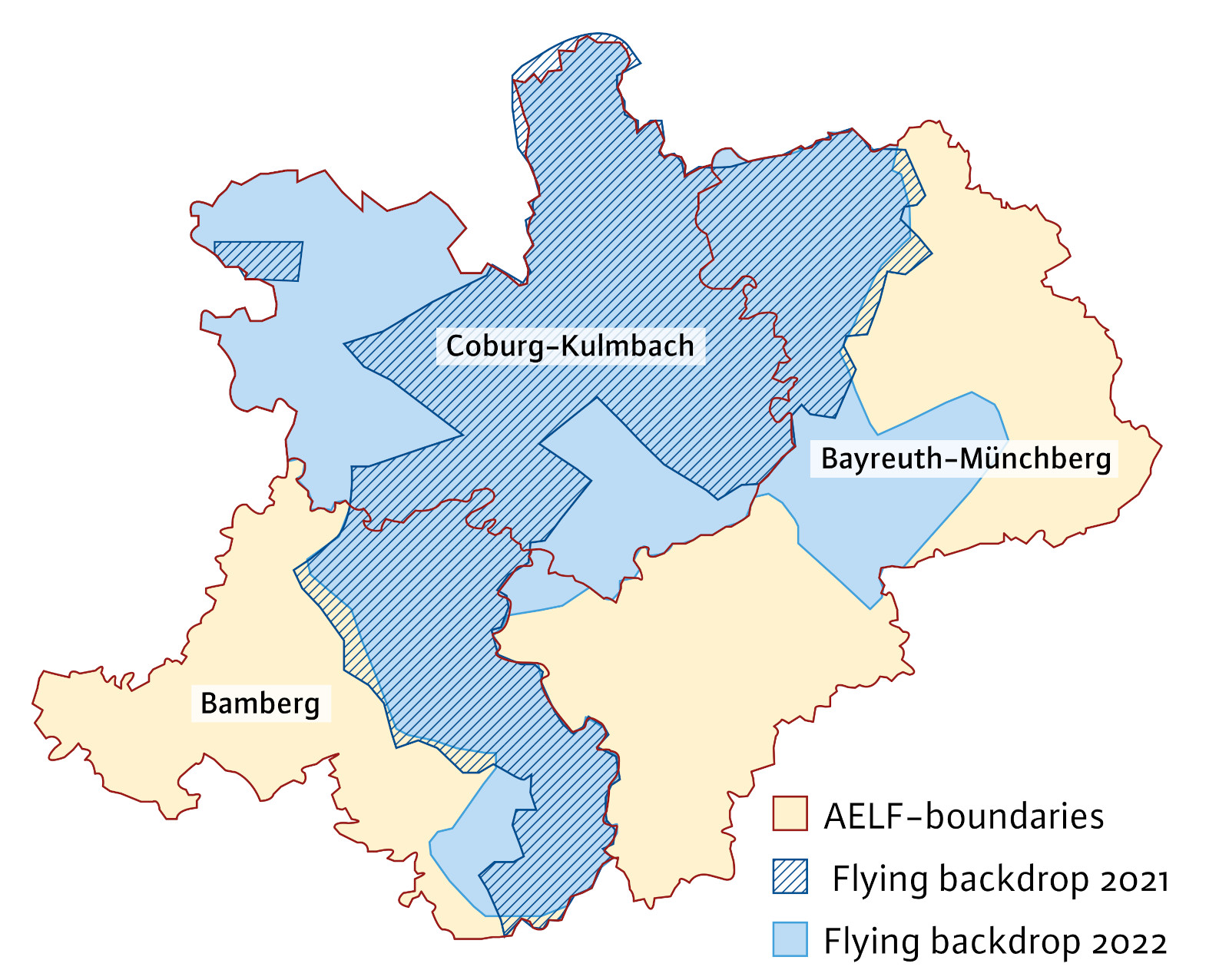
Fig. 2: Areas covered by the fast orthophoto image flights commissioned in Upper Franconia.
In August 2021, the Bavarian State Ministry of Food, Agriculture and Forestry commissioned the LWF to carry out a fast-orthophoto image flight over a 2,840 km² area in Upper Franconia in order to support the food, agriculture and forestry offices (ÄELF) in Bayreuth-Münchberg, Coburg-Kulmbach and Bamberg with the detection and recording of bark beetle damage. The flight path is shaded dark blue in Figure 2. The commissioned company carried out the image flight on 8 September 2021 in cloud-free conditions. The image data from the fast orthophoto survey was made available to the authorities on 14 October 2021. The affected ÄELF offices for food, agriculture and forestry thus received a complete overview of the bark beetle damage areas 36 days after the aerial survey. Due to the positive feedback from the offices, a further fast orthophoto image flight was commissioned in 2022.
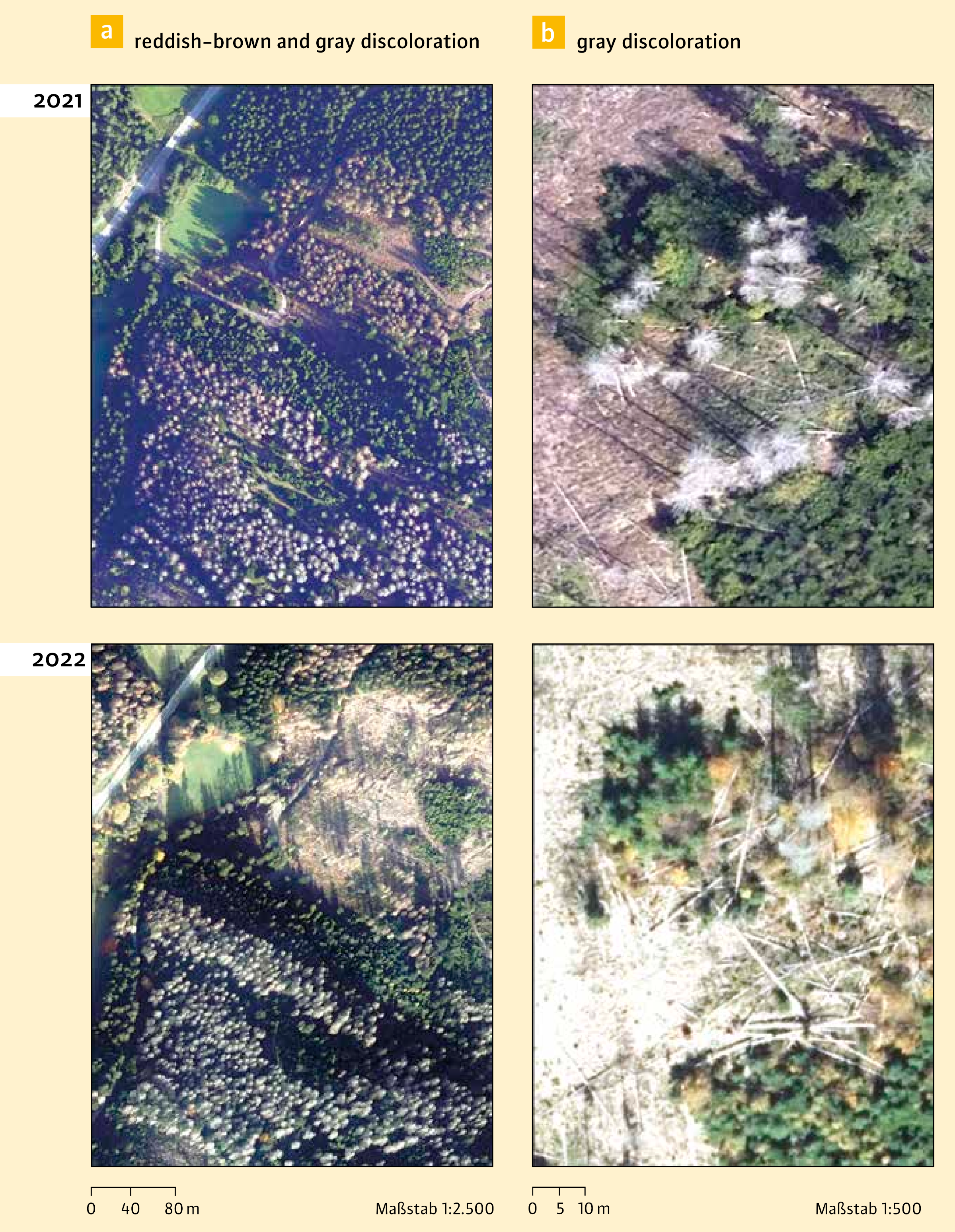
Fig. 3: Excerpts of the fast orthophotos from autumn 2021 and 2022 in true colour.
As the infestation had spread further, it was planned this time to cover an even larger area totalling 4,220 km² in the aerial survey. This is shown in light blue in Figure 2. Due to the unfavourable flying weather in September and October 2022, the image flight had to be put together from three separate flights (23.9, 9.10., 20.10. 2022). The data was made available to the ÄELF offices in BayWIS on 23 November 2022, i.e. 34 days after the final flight.
Figures 3 and 4 show examples of some sections of the fast orthophotos from the flights that took place in the autumns of 2021 and 2022. The pictures show sections of the Franconian Forest. Later stages of infestation, in which the tree crowns have turned reddish-brown or grey, can be easily identified. By comparing the fast orthophotos from 2021 and 2022, the progression of the damage during this period can be analysed and documented. In this context, Figure 4 shows that the emergence of bare patches can be visualised very clearly.
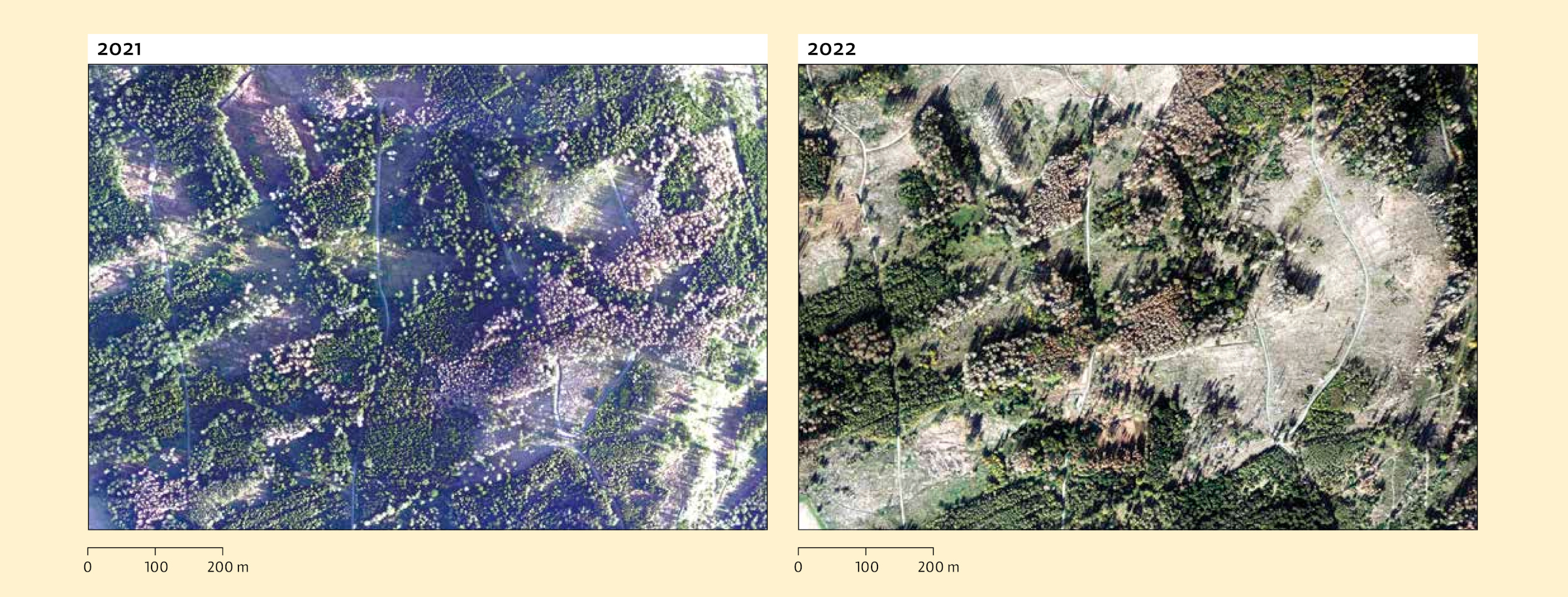
Fig. 4: A comparison of the fast orthophotos from 2021 and 2022 shows where bare patches have developed within a year.
Positive feedback from the foresters in the field
According to feedback from the ÄELF offices, the fast orthophotos made it possible to record the forest areas damaged by the bark beetle over large areas. The ÄELF saw the image data as a valuable tool assisting them in their work, as infestations and the direction of their spread could easily be derived and tracked. Additional information made it possible to identify and seek out affected forest owners and inform them accordingly. The ÄELF thus described the data provided via BayWIS as “another important piece in the mosaic of information allowing us to provide good advice to forest owners”.
However, image analysis does reach its limits in certain topographical locations: especially on steep slopes, too much shade impaired the recognition of damaged areas, depending on the time of recording and light conditions. This was due to the late flying dates in September and October and the correspondingly low position of the sun.
Automated detection of clear areas with surface models
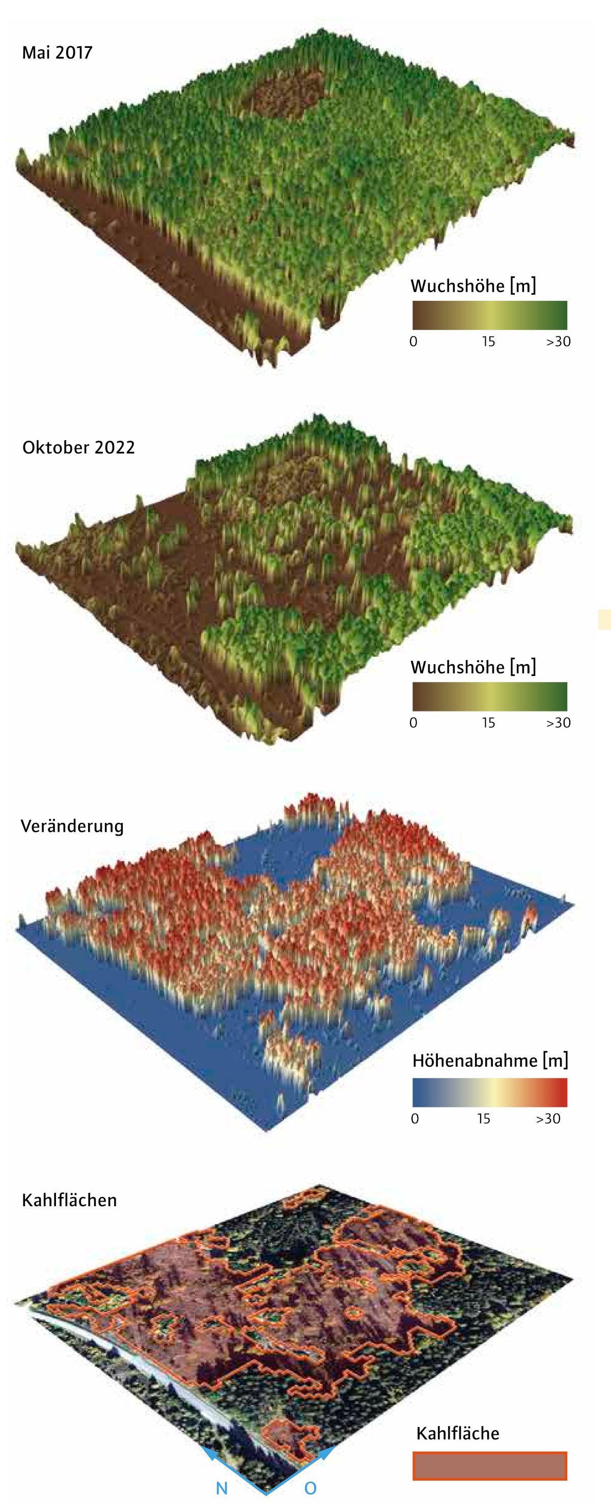
Fig. 5: Three-dimensional view of a forest area in the Frankenwald forest (size: 15 ha). All four illustrations show the same section. The top image shows an official surface model from May 2017. Below it is the calculated surface model from the fast orthophoto aerial survey of October 2022. The change or decrease in height between the two recording times was derived from this. In the diagram, all height increases are assigned the value zero (height increases can be caused by height growth, for example, or by local inaccuracies in the models). The change is shown in the third image. Due to the calculation method, the trees that have disappeared (differences) are in fact shown standing (in red). The unchanged (crown) areas are shown flat (blue). The bottom image shows clear areas automatically demarcated by the fast orthophoto.
The mapping of clear patches in the damaged areas as precisely as possible is an important basis for the planning of reforestation that is adapted to the site. Up to now, the ÄELF offices have recorded clear-cut areas manually using the fast orthophotos provided. In order to make the time-consuming manual mapping more efficient in future, the LWF is currently examining automated recording methods. Great potential for successful automation is seen in the evaluation of digital surface models (DSM). A DSM is a spatial representation of the earth's surface, including natural and man-made objects on it, such as vegetation and buildings, for example. With the appropriate software, a DSM can be calculated automatically from orientated stereo aerial images. In this way, the Bavarian Surveying Administration has been producing surface models with a spatial resolution of 0.40 metres since 2015. These are available for the whole of Bavaria, based on the aerial photographs taken regularly in the course of the Bavarian Aerial Survey.
In order to determine which clear-cut areas have developed in a study area in a particular period of time, two surface models with different recording times are compared with each other (change analysis). This procedure is shown schematically in Figure 5. Growth area 8.1 Frankenwald (Franconian Forest) served as an example of a study area. In this case, a DSM of the Bavarian Surveying Administration was selected as a reference, representing forest condition at the end of May 2017. The height comparison was carried out using a DSM calculated from the stereo aerial images of the fast orthophoto image flight made in autumn 2022. The decrease in height from May 2017 to October 2022 shows where clear areas have potentially developed. As Figure 5 illustrates, polygon areas are delimited from these in the final processing step.
However, there are also reasons for a reduction in height that are not related to the processing of damaged timber. In the case of hardwood, for example, leaf shedding in autumn can cause a reduction in height. In addition, the low position of the sun in autumn and the resulting long shadows can lead to errors when it comes to creating the surface model. It is therefore important to check the automatically generated results manually. Sources of error were reduced by including additional geodata. A tree species group map created at the LWF could be used to exclude hardwood areas from further processing steps; in addition, small automatically recorded areas with a size < 250 m² had to be removed, as the automated recording works less reliably here.
The accuracy of the automated clear area detection was randomly checked in the GIS using visual image interpretation. For this purpose, the LWF randomly distributed 630 sampling points within the forest area. At each point it was checked whether the automatically generated result matched the visual impression in the orthophoto. The transitional areas between clear areas and unchanged forest areas were also taken into account, as experience has shown that the accuracy of the automated evaluation is lowest there.
The validation revealed an agreement (F1 value) of 91% between the automatically calculated and the visually confirmed clear areas. The comparison of the DSM derived from the fast orthophoto flight of 2022 with the official DSM from 2017 was therefore highly suitable for mapping the clear areas that had developed. The analysis showed that a total of 71.73 km² (± 0.78 km²) of clear areas appeared in the Frankenwald forest between May 2017 and October 2022 - corresponding to 15 % of the total forest area in growth area 8.1 in the Frankenwald forest. Standing deadwood is not included in this calculation, however, as no clear decrease in the vegetation heights was observed in the surface models analysed here.
Conclusion and outlook
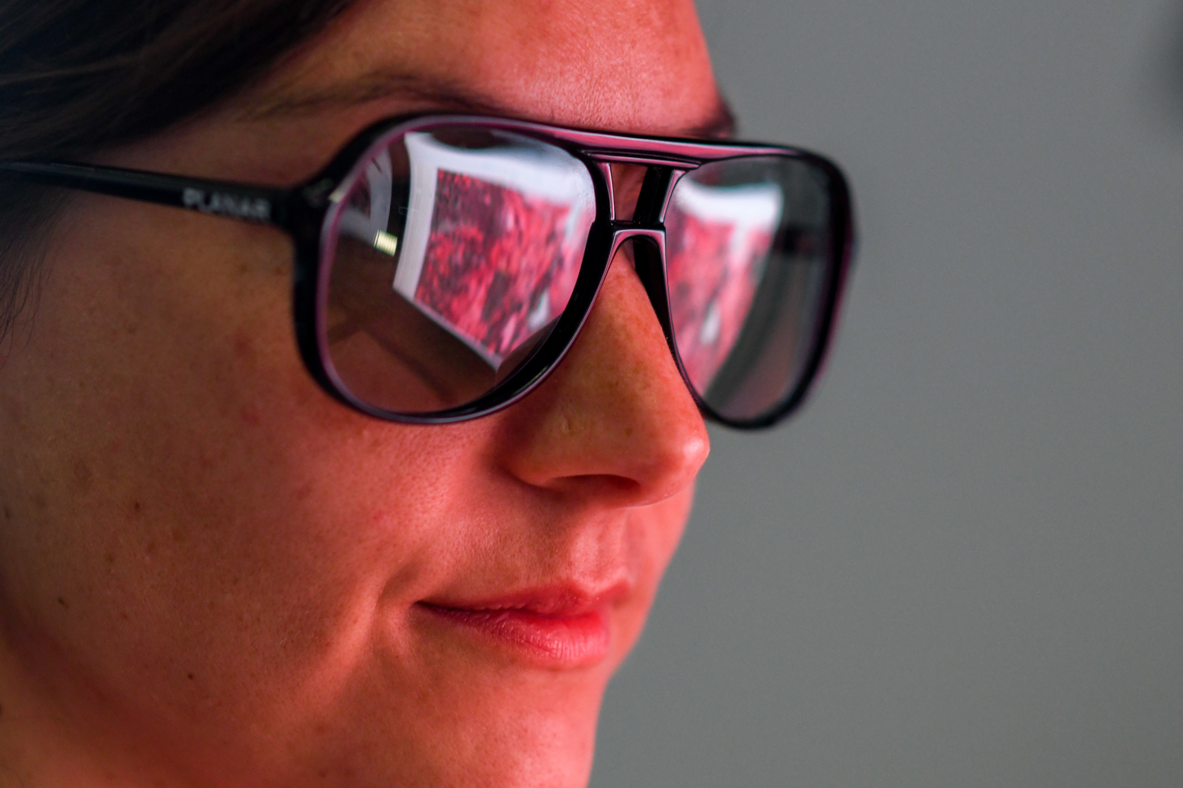
Fig. 6: The time required to analyse the aerial images is still relatively high; whether it can be reduced with the help of modern AI methods remains to be seen. Photo: Tobias Hase, Bavarian State Ministry for Food, Agriculture and Forestry (StMELF)
Although the evaluation of aerial photographs cannot replace field surveys, it does make it easier to localise infestation sites and thus helps with the advising of the affected forest owners. Visual image interpretation can be used to differentiate between spruce trees with reddish-brown discolouration and spruce trees with grey discolouration in the fast orthophotos, so that such later stages of infestation can be identified. However, early detection (green-attack stage) is not possible with the image material provided.
In future, the aim is to automate the evaluation of the near-orthophotos as far as possible in order to reduce the time required to analyse the images. Modern AI methods such as deep learning - a sub-area of machine learning - will also be tested. Whether these methods can be used to create a robust, reliable model for the detection and recording of discoloured spruce trees that can be applied to different image data sets in future remains to be tested.
The calculation of a surface model from the stereo aerial images of the fast orthophoto flight of 2022 was successful. Its comparison with an official surface model from 2017 made it possible to delineate clear areas with a high degree of accuracy. Although manual correction of the results is necessary in places, a high degree of automation has nevertheless been achieved. In the future, it should be tested whether alternative remote sensing techniques - especially with airborne laser scanner measurements - enable even more precise mapping of clear areas.
Summary
In 2021 and 2022, the LWF commissioned large-scale aerial surveys in Upper Franconia to support the local Offices for Food, Agriculture and Forestry (ÄELF) with the detection and recording of bark beetle damage and clear. The processed image material was to be made available to the ÄELF forestry offices as quickly as possible - something which was achieved thanks to so-called “fast orthophotos”, produced in a rapid process and made available via BayWIS. The image data proved its worth in localising infestations, and is thus considered by the ÄELF foresry offices to be a valuable working basis. In addition, the LWF also investigated ways of automatically detecting and recording bare areas using surface models - an approach which has proved to be promising and is being pursued further.