
What exactly is meant by protection forest?
As long as everything is fine, we are often not even aware of the protection forest. On a hike through the mountains, we may see trees or the forest, but we are rarely aware of the important protective function they have - even though in the Alps in particular, many areas are designated as protection forest.
Protection forest is important. Why? Essentially for two reasons: A protection forest is intended to protect us humans, our infrastructure, and our cultivated areas from natural hazards, such as floods, avalanches, rockfall, mudflows or landslides. And, no less importantly: A protection forest is also intended to protect its own site or a neighbouring forest under particularly difficult conditions. So in the first case it is more about our own protection; in the second case it is about protecting the forest ecosystem itself.
We cannot take the protection of a protection forest for granted, however; it also requires our intervention again and again. Climate change and the extreme weather events that accompany it, such as heavy rain and storms, represent a challenge for the protection forest in two ways: firstly, the effectiveness of its protective function is challenged (more water must for example be retained and stored rapidly during heavy rain); and, secondly, its own stability is put to the test (the forest stand itself must survive the hurricane, for example, or at least recover quickly). The primary task of protection forest management is to take silvicultural measures to maintain the protective function and stability of the forests (protection forest tending). Where forests have lost their protective effectiveness, it is necessary to restore this with rehabilitation measures. Because of the protection gap alone, it should however if at all possible not be allowed to come to this. If the rehabilitation of a protection forest should nevertheless become necessary, it is usually a lengthy and costly process, as the re-establishment of a young stand without adequate protection from the old trees is usually difficult, especially on alpine sites.
Although we think of protection forests primarily in terms of the protection they offer against natural hazards, measures taken to strengthen protection forests also serve to preserve or restore valuable forest ecosystems, to store carbon, to protect the soil, and ultimately to protect the landscape and promote recreation.

Fig. 1: Especially in the Alps, many areas are designated protection forest. Photo: Boris Mittermeier
Judiciously deployed remote sensing by drone
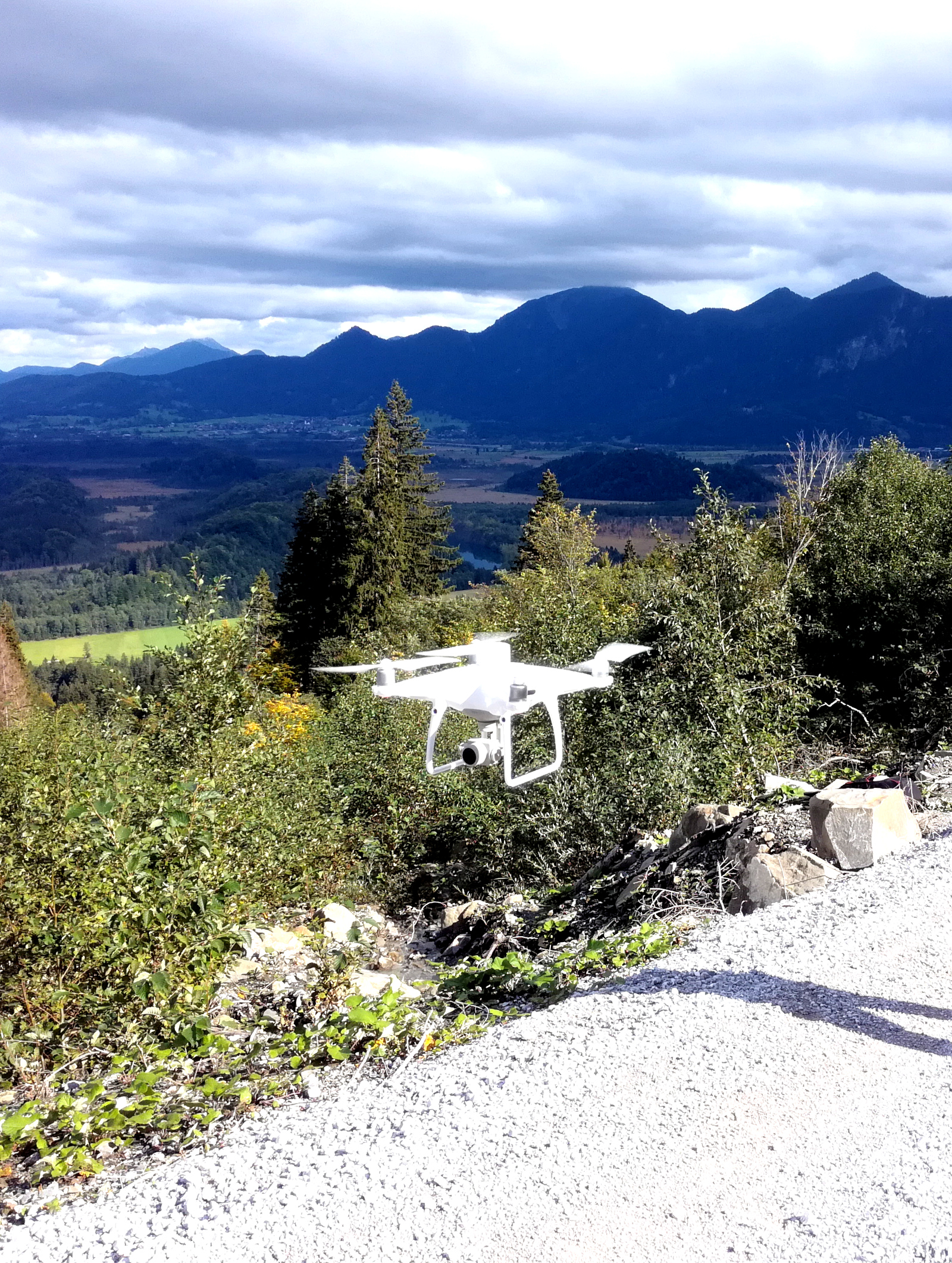
Fig. 2: Drone deployment in the protection forest. Photo: LWF
Through remote sensing with drones, we aim to facilitate the future management of protection forests in two areas in particular: on the one hand, by identifying the need for tending measures in the protection forest as early as possible; and on the other hand, by facilitating success checks and the monitoring of protection forest restoration, and more efficient control of the measures taken. Compared to aircraft, drone-based remote sensing is cost-effective and flexible. It provides high-resolution data and thus has great potential for the surveying and monitoring of protected forests in particular. The deployment of UAVs (Unmanned Aerial Vehicles) can be particularly advantageous in alpine terrain, which is sometimes difficult to access. Used correctly, remote sensing by drone is an extremely low-disturbance technique that can benefit sensitive species. The alpine habitat and its morphological peculiarities require carefully adapted planning for all flights, however. This includes: consideration of all prior information on flight safety and nature conservation; GIS-supported selection in advance of central take-off sites with good visibility; and flight control that is adapted to the steep and varied terrain and the respective growing stock, to name but a few.
SANDRO project launched
To take advantage of this potential in practice and scientifically, it is first necessary to test and develop suitable procedures. The SANDRO project comprises several work packages. One work package is to adapt the flight planning to the special conditions of the alpine terrain, as flight safety is the first priority. An important prerequisite for good flight results is so-called “terrain following”. This means that the drone autonomously follows a precisely proscribed flight path while maintaining a constant distance from the surface.
As the Alpine region is a hotspot of biodiversity, we also want wildlife to benefit from low-disturbance remote sensing. Appropriate flight planning, e.g. the judicious selection of flight time and altitude, should ensure this is the case.
One central challenge is to identify important parameters of the forest structure and their protective effectiveness from the drone perspective. A ground resolution of 1-2 cm is no problem with aerial drone images, so that even the smallest tree plant is recognisable and its development can be observed over the years. Two different methods are used to measure the height: Photogrammetry (in the UAV sector also “structure from motion”) and laser technology (LIDAR - Light Detection and Ranging).
For photogrammetry, photos are taken that overlap considerably during the flight. Through the changing camera perspective during the flight, the position of identical pixels or pixel patterns, also detected by the special software, can be calculated in 3-dimensional space. This means you can even measure tree heights quite accurately on the basis of normal photos.
The laser method, on the other hand, is technically more complicated: During the flight, huge numbers of (harmless) laser pulses are emitted, and reflected - by a leaf, for example. A sensor receives this reflected light and can calculate the position of the leaf (ultimately just one point on it) via the time the laser pulse takes to travel there and back and the direction of the laser pulse, which is also known.
Test flight with promising results
Last spring, shortly after the snow melted, we carried out a first test flight in the mountain forest. The section shown (Figure 3, top) shows a gully in the Fahrenberg protection forest restoration area above the Walchensee lake. Such gullies are likely avalanche paths, as the snow concentrates here. For avalanche protection, it is primarily the start and feed zones that are decisive. A three-dimensional model was generated from the aerial photographs, ultimately consisting of lots of individual points displayed in true colours. The aerial photograph itself is much sharper.
The aim was to use this as an example to automatically detect the trees of very different sizes and to determine their height. First, the ground points were determined with a so-called "cloth simulation filter". The name comes from the fact that a simulated digital cloth is applied to the lowest points from below. In the levelled model, local maxima were then determined with a search window dynamically adapted to the respective point height (and thus to the expected crown width). Once the green points had been filtered by means of a vegetation index, the heights of the tree tops were finally obtained, ranging from 50 cm to just under 19 m. Test successful: The detection of trees of very different sizes next to each other obviously works well.


Fig. 3: Automatic single tree detection and height determination of a sparse spruce stand with a wide range of tree heights - between 0.5 and 19 m - based on overlapping aerial images from a drone (digital photogrammetry); top: real relief; bottom: normalised to ground level
Figure 4 shows a classic rehabilitation situation: a grassy, steep, south-facing slope. Since the young tree plants here are at grave risk from movements of snow, tripods made of durable sweet chestnut have been installed to protect the trees planted in small clusters. There are nevertheless always losses in such difficult locations, and it is often several decades before the remaining trees take on a protective function themselves. It can be judged very well from the aerial photograph whether replanting or gap-filling measures are necessary. Using the same method as in the example above, 103 young green conifer plants were identified on an area of approximately 340 m². This corresponds to around 3,000 plants per hectare - an acceptable value in itself, although most of the young plants protrude just 20 cm above the still snow-flattened grass, and only a few specimens have already exceeded the 1 metre mark.
In terms of method, it can be stated: On forest areas that have been significantly opened up and exposed to a lot of light, photogrammetry can be expected to be a very suitable method, especially in combination with multispectral data (for the vegetation index).

Fig. 4a: UAV aerial image of a densely grass-covered rehabilitation area, with wooden tripods and clusters of conifers (aerial flight with vertical take-off drone, ground resolution just under 3 cm).
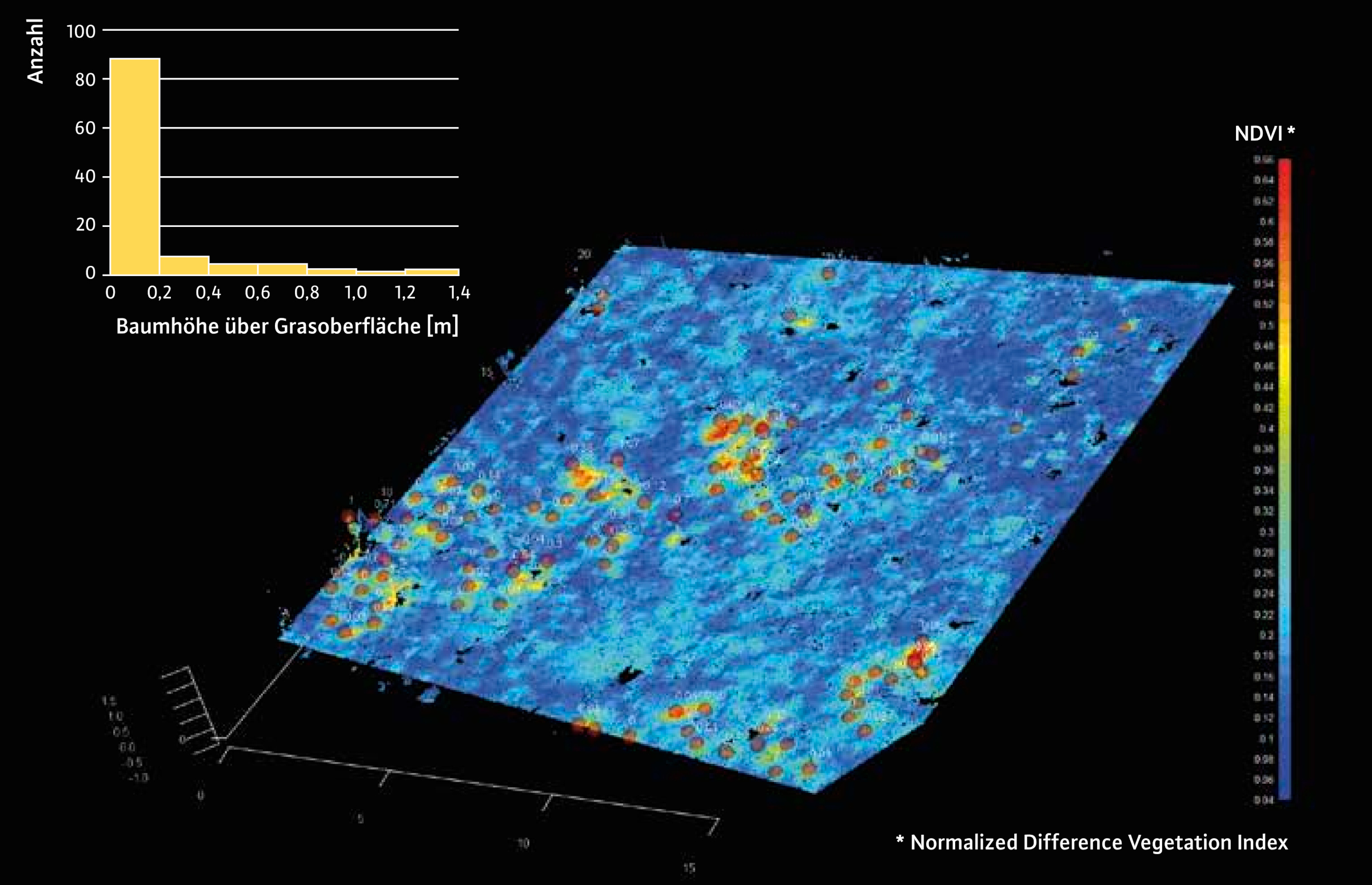
Fig. 4b: Automatic single tree detection (red dots) and height distribution of the wintergreen young trees planted in rehabilitation measures.
Growing up in the “forest nursery” - a look under the canopy
Constant forest cover, i.e. a permanent forest, is crucial for fulfilment of the forest’s protective function against all natural hazards. It is best if shade-tolerant young plants, especially beech and fir, take seed while under the protection of the still relatively closed canopy of the old trees (in the forest nursery, so to speak), so that they are already in the starting blocks when a gap arises. When a gap arises, the more light-demanding species of the mixed mountain forest such as spruce and sycamore then also find their place. This leads to the development in phases of a structurally rich protection forest with trees of different ages. Even young trees contribute to the roughness of the terrain - an important factor in preventing snow gliding or the surface run-off of precipitation. They are also the best “insurance” for the preservation of the protection forest, in case of a major disturbance caused by bark beetles or storm damage.
A great advantage of laser-based remote sensing (LIDAR) is that it also gives us a view under the canopy of the older trees. The active laser light pulses work well in the dark shade of the crowns, and due to their large number, a few always reach the lower tree layers and the ground.
This view under the canopy is very important for the assessment of future forest development and the early detection of potential problems. The vast majority of our protection forest rehabilitation areas have occurred as a result of the failure of young trees to come up. Browsing by game often plays a decisive role here. If the old trees are lost due to their age, bark beetles or storms, the protection forest sooner or later also disappears - and the cost is then huge.
Figure 5 shows a forest plot in the laser point cloud. In the detailed view, young trees are already visible under the old spruce trees. In this example, they could also be delineated in the computer by clustering. The data came from aeroplane flights in this case however, which to date (unfortunately) are repeated only irregularly or at long intervals. From the drone, far greater point densities are possible, which should make the automatic detection of the regeneration even more reliable. Since this is not possible over a large area, however, we want to combine the different data sources and their advantages: The high-resolution aerial drone image can be used to check whether regeneration has emerged in larger gaps; the aircraft laser looks under the crown canopy over a large area; the drone laser provides more and up-to-date details for sub-areas, e.g. for flyover strips.

Fig. 5: The view under the canopy: "Full wave" LIDAR data reveal the regeneration under the canopy of the old tree stand even from an aircraft - an important criterion for a lasting protective effect of the forest (Geobasis data: Bavarian Surveying Authority).
It's the interaction that counts
Of course, protection forest management has always included success checks and the efficient planning of measures. These have up to now been based mainly on purely terrestrial methods, however, i.e. surveys from the ground. We aim to supplement and make this easier in future. On the basis of the detailed aerial photographs alone, area inspections can now be planned in a more targeted manner, although some things can still only be done from the ground (e.g. the assessment of causes when losses or growth stagnation are observed). With the drone data, we can cover large areas comparatively quickly, however, and we can derive measurement data such as tree heights or the degree of cover automatically. Eventually, it should become a hybrid process.
Summary
Protection forest offers protection from natural hazards and protection for forest ecosystems in equal measure. In protection and mountain forests, remote sensing by drone can really come into its own. Judicious and professional planning and implementation is essential. Initial trials show that with aerial photography, photogrammetry and LIDAR, important parameters of the protection forest, its development, and the effectiveness of its protection can be collected quickly and flexibly. In the SANDRO project, we are developing remote sensing by drone for the protection forest and working out concepts for a hybrid procedure in combination with existing terrestrial monitoring.
The SANDRO project is being funded by the Bavarian State Ministry of Food, Agriculture and Forestry (Running time: January 2023 to December 2025) and carried out in cooperation with the specialist agencies for protection forest management.
